

By Deborah Archuleta-Moreno
There are many places in New Mexico that I have come to admire and appreciate, and one of the most enchanting places New Mexico has to offer is the area of the Rio Grande called Wild Rivers. Here at BLM’s Wild Rivers Recreation Area, the Rio Grande and Red River waters twist and turn through a plateau of old volcanic rock deep within rugged canyon walls.
The Wild Rivers Recreation Area is part of the Rio Grande del Norte National Monument, designated as a Wild and Scenic River, located in the high desert of northern New Mexico. Three miles north of Questa, NM, you turn westward on Highway 378, the road that leads you through the village of Cerro. This small village dates to the 1850s and is proud of its history. Following through Cerro, you will drive towards open land that leads to the basalt cliffs of the Rio Grande. There is a large national parks sign at the entrance to the public lands.
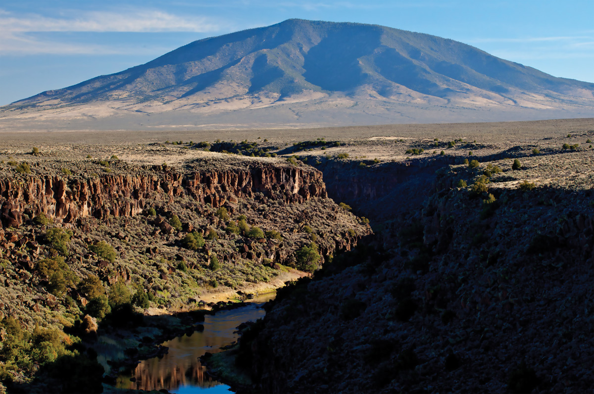
Looking northward from Wild Rivers, you will see Ute Mountain, known to the locals as La Yuta, an extinct volcano that sits on the northern end of the Rio Grande del Norte National Monument. Ute Mountain is very prominent when seen from the Village of Cerro. On some days, you might see clouds covering the top of the mountain. My grandfather would say, “If there is a hat on the Ute, then we know we will be getting weather,” an old-timer’s way of forecasting the weather per se. Sometimes there is a brim on the hat, with the peak poking through, which old-timers say indicates snow. Often Ute Mountain isn’t visible at all, because of low clouds, fog, or more recently, smoke from wildfires.
La Yuta was known as a place of peace. This is where Native peoples would meet for trading, even after the Spanish came and settled in the area. There is much evidence of these tribes trailing down through the Rio Grande Canyon, where they gathered and used natural resources. There are native plants that grow along the river that the indigenous peoples and early settlers used for both food and healing purposes.
If you hike down from the rim of the cliff on the Big Arsenic Springs trail, you will come to petroglyphs left behind by ancient peoples. You can then follow the trail to the springs which sits at the end of the trail, or you can continue along the river and walk towards Little Arsenic Springs and loop back up to the rim.
Most of the early settlers in this area were sheepherders. My grandfather and his family were among them. They would walk the sheep down the canyon cliffs to the Rio Grande, and cross the sheep over to the other side of the canyon. This first campground at Wild Rivers is called Sheep Crossing. Not only is this recreation area used for camping and fishing, but many of the locals enjoy it for family gatherings.
The many campground sites are well maintained and there is much wildlife in the area to enjoy. Be careful, though, be on the lookout for rattlesnakes! You might want to tie a piece of osha root to your shoelace, a trick from both Native peoples and old-time ranchers, to keep the snakes away. Osha root is a wild celery that grows in the Sangre de Cristo Mountains. It is a widely used traditional herbal medicine used as an immune booster, helping with colds, flu, pneumonia (as well as keeping rattlesnakes away) and some curanderas say that it will even keep witches away!
Wild Rivers is a place where you can find peace, quiet, appreciation of grandeur, and solitude. You will find that the fragrance of piñon and juniper fill the air, and you might get a glimpse of a red-tailed hawk, come into contact with a mule deer, or bighorn sheep. Everywhere you look, the view is spectacularly scenic, however the overlook with the most striking view is La Junta Point, where the Red River and the Rio Grande meet.
Not only is the view spectacular, but here you will find the La Junta Trail, one of the better hiking trails. As of mid-May, the La Junta Trail was still under renovation. You may want to check with the Taos Field Office before planning a La Junta hike, at (575) 758-8851. If it is open, you can hike down the 800-foot canyon cliff to the confluence of the two rivers. The La Junta trail can also be done as a loop by taking the Little or Big Arsenic trail(s) and hiking back to the La Junta trail.
It is the perfect for a day hike or a few days of camping, a wonderful getaway from the hustle and bustle of everyday life. You will find Wild Rivers to be filled with wonder and beauty. For anyone who wants to enjoy breathtaking dramatic views and experience a quiet, rugged and natural environment, the Wild Rivers Recreation Area of the Rio Grande del Norte National Monument, is the place to be.
More about Wild Rivers Recreation Area: There are five campground areas—each equipped with tables, grills, drinking water, and restroom facilities. One of the camping areas at the base of the canyon has 16 primitive campsites. There are two large group camping sites. In total, there are 40 campsites available at Wild Rivers. Camping is permitted in designated sites only. To protect vegetation, please use hardened tent sites only. Group shelter reservations are made by submitting a request through BLM_NM_TAFO-Admin@blm.gov.
The Zimmerman Visitor Center on the main loop road provides information about the recreation experiences to be had in the WRRA as well as about the geological and natural history of this diverse and interesting area. The Visitor Center reopened for the 2022 season on Memorial Day weekend. For more information, contact the Taos Field Office at (575) 758-8851. https://www.blm.gov/visit/wild-rivers-recreation-area